
“The opposite of a city with strong visual character is faceless sprawl.” — from The Image of the City by Kevin Lynch
The Hollywood Park neighborhood on Chicago’s Far North Side has a lot of things going for it, but clear-cut borders aren’t one of them. When I asked 10 former residents of Hollywood Park to recall the boundaries of the neighborhood, I expected a few different answers. What I got was seven different versions of Hollywood Park. Here they are:
- “I have no idea what the ‘official’ boundaries are, but to my childhood mind they were probably Peterson to the north, Central Park to the west, Bryn Mawr to the South and Kedzie (Jersey) to the east.”
- “Foster to Lincoln and Kedzie to Pulaski”
- Peterson to the north, Kedzie (Jersey) to the east, Kimball to the west, and Bryn Mawr to the south”
- “The river on the east; Pulaski to the west, Devon to the north and Bryn Mawr to the south”
- “In no specific order and more feeling/memory-wise than strict geography: Peterson/Pulaski intersection, Lincoln Village shopping center, Peterson school/Christiana Ave., Jersey Ave.”
- “Peterson, Kedzie, Foster, Pulaski”
- “Hollywood Park to Von Steuben, Kedzie to Central Park”
- “I would say Foster Avenue on the south, Pulaski Road on the west, Califoria Avenue on the east, and Devon Avenue on the north.”
There’s no right answer. And that’s true for just about every Chicago neighborhood.
The official version

Chicago’s 77 communities (http://thechicago77.com)
In the late 1920s the University of Chicago identified 75 communities in the city and two more were later added. The community designation is used for the census and some municipal functions.
Hollywood Park was one of several neighborhoods included in the North Park community, but it’s the only one of the bunch that routinely gets called North Park instead of its actual name. Not that it matters. Neighborhoods themselves have no official designation or purpose and they’re always changing.
What we learned in school
Back in the day, Chicago children acquired an early, strong sense of their neighborhood’s borders because they didn’t have to venture outside them to attend school. In Hollywood Park the connection between school and neighborhood was particularly strong. The elementary school and high school were on the same street, Kimball Avenue, just five blocks apart.
On the northern and southern edges of Hollywood Park, however, neighborhood and school boundaries didn’t quite line up. Some survey responses corrected these border discrepancies by extending Hollywood Park neighborhood boundaries to match up with the boundaries for the local elementary school, Peterson.
A street with two names
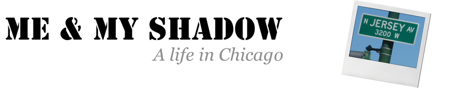
Hollywood Park suffers another conceptual difficulty on its eastern border. For nearly 23 miles in Chicago, the north-south street at 3200 West is Kedzie. Except in Hollywood Park, where 3200 West is Jersey Avenue.

The mystery behind this street name is on my list of things to look up, but I do know this: a street with two names might as well be a street with no name in the minds of people who aren’t all that familiar with the area.
Why choose–have both
In the beginning, there was North Park. When it was founded in the 1890s by a group of Swedish immigrants, Hollywood Park had not yet appeared in the dreams of real estate developer Oliver Salinger.
At one time the two communities must have seemed distinctive, Swedish North Park and Jewish Hollywood Park. One survey participant who attended Peterson School wrote:
“We referred to our neighborhood as North Park. I was vaguely aware of there being a Hollywood Park region nearby but I don’t think I ever had a concept of where it was, just that kids who lived there attended Peterson School with me.”
In the mid-1960s and later, most residents probably still thought of Hollywood Park and North Park as separate communities, but as demographics changed the boundary between them became less meaningful. The solution has been to combine the two. On the 39th ward website, for example, the community is called Hollywood Park/North Park. Another example is the Hollywood Park-North Park Community Association.
What does it mean when people who lived in a community disagree on its boundaries? Do blurry boundaries weaken a neighborhood’s identity? Do they have an economic as well as a social impact on a community?
One indication of the importance of borders to neighborhoods are Chicago’s neighborhood gateway structures. A stylized Puerto Rican flag arches across Division on the road to Humboldt Park, architectural columns welcome visitors to Greek Town and rainbow pillars mark the threshhold of Boystown.
Imagine if the city had built a gateway to Hollywood Park-North Park back in the 1960s. Where would they have put it? And what would it have looked like?
Related posts: Part one of this series on the image of a Chicago neighborhood in memory. Also see, Where I Grew Up, a page with links to all my Hollywood Park posts.
Sources: This series of posts is based on my reading of Kevin Lynch’s, The Image of the City.

Nice to hear from you again, Paul. You’re right on all counts, I believe. The turnaround on Kedzie near Peterson disappears on aerial photographs between 1972 and 1988. It was replaced by the expansion of the McDonald’s parking lot. I never rode the Kedzie bus because I had to go west of Kimball to get home, but I did ride the 82 to the Ravenswood station for many years. At some point I realized I could also take the Peterson bus to the Bryn Mawr Station for the Howard line and get downtown that way with less walking.
I don’t know exactly when the Teachers College was built, but it was fairly new in 1961 when my mother started to teaching there. It was about that time the school changed from a teacher’s college to a full liberal arts degree program. I know from a Peterson classmate that the lot was empty in the late 1940s and it was still an empty lot on an aerial shot dated 1952. And most people who lived in Hollywood Park back then would agree that the neighborhood extended to Central Park north of Bryn Mawr.
Dear Ms. Archer,
I’ve written to you before and periodically check the “Hollywood Park” websites you have.
I’d like to discuss the CTA bus turnaround at Kedzie/Peterson that you mentioned.
I lived at 5510 N. Sawyer Ave. and when I had to travel downtown, I would almost always walk to Kimball and Catalpa and take the Kimball bus line 82 southbound to Lawrence Avenue and there transfer onto the Ravenswood L. When I would return home during evening rush hour, I could either go home the way I had come, or else I could get off the Ravenswood L at Kedzie. Most northbound Kedzie buses turned right at Foster Avenue and continue eastbound to California Avenue, then northbound again. However for a time there was an occasional northbound Kedzie bus that would have the headsign: “Kedzie-Peterson” and, as the sign read, continue northbound on Kedzie until Peterson. I would get off the bus at Kedzie and Catalpa and walk 1/2 block to Sawyer instead of the 1 1/2 blocks to Sawyer from Kimball. HOWEVER, the Kedzie-Peterson bus ran so infrequently that after a while I just took the Ravenswood L to Kimball and rode on the 82 which ran much more frequently. As far as the name “Jersey Avenue” goes, that street extended only four blocks: from Bryn Mawr to Peterson. North of Peterson, “Jersey” was called “Kedzie” again. Let me put in my two cents about the boundries of “Hollywood Park.” Hollywood Park was between Foster and Peterson and between Kedzie and FORMERLY Saint Louis Avenue. I say “formerly” because when I lived there, the Chicago Teacher’s College hadn’t yet been built and there was nothing west of Saint Louis Avenue south of Bryn Mawr. North of Bryn Mawr Avenue, Hollywood Park ended, I believe, at Central Park Avenue. Please correct me if I’m mistaken.
As Bob Hope would say: “Thanks for the memories…”
Paul Malevitz
Thanks for visiting. I totally agree. Bucktown west of Western? Really?
Travel about a mile west of Hollywood Park on Peterson Ave, and the following question arises: What are the boundaries of Peterson Park? Travel yet another two or three miles west on Peterson/Caldwell – beyond the Edens Expy -, and now it gets really tricky: What are the boundaries of Wildwood?
My take is, it’s not science. Boundaries of micro-neighborhoods in Chicago constantly move, get re-named, and are even re-invented. West Bucktown to describe East Humboldt Park, for instance. West Bucktown was a Developer and Realtor invention – coughcough – a few years back. Now, it seems to be a generally accepted name for a geography around Western and North Ave.
Great post. I’m bookmarking your blog.
I do remember something happening in the sixties with Jersey. Was there an attempt to change it back to Kedzie for consistency and the effort failed? I’ll try to find out next Tuesday evening at the Hollywood Park-North Park community meeting. Do you remember there used to be a CTA bus turnaround just south of McDonalds? Maybe that had something to do with the city wanting to change the street name.
1957? I could have sworn that I remember when that part of Kedzie turned into Jersey and I was born in 1959. Are you sure that change didn’t happen in the mid to late 1960s?
Ellen, thank you for providing the background on Jersey/Kedzie. Not that it makes sense. Actually it does a little. The original marketing materials for some of these outlying neighborhoods promised close-in convenience with a surburban or, in the case of the Villa neighborhood, a rural feel. I’ve been wondering about the West Ridge name myself. Particularly because one local history website claimed West Ridge was the area north of Peterson extending all the way to Pulaski! Which is of course ridiculous. L’shana tova.
Frances,
According to the book Streetwise Chicago, A History of Chicago Street Names, by Don Hayner and Tom McNamee, Jersey Ave., 3200 W. from 5600 N. to 6126 No., takes its name from Jersey City, New Jersey, or from Jersey, one of the English Channel Islands. “In 1957 the people living on this stretch of what was then Kedzie Ave. felt their street needed a name that didn’t make people think of factories, noise and dirt. So they named it Jersey.”
FYI
I enjoy reading about your neighborhood. Someday I’d like to do the same about mine, what I called West Rogers Park but today seems to be known as West Ridge.